
Description
As a complete workflow management solution, UAV technology allows you to process and analyse millions of data points gathered from above and to visualise the data to provide actionable information. UAV data can be combined with existing survey technologies, such as TPS, GPS, and laser scanning providing a more complete set of information. By taking only minutes to survey a site, UAVs enable the completion of projects at a lower cost and with fewer staff.
This flying platform is specifically designed for professional industrial applications. The modular design makes this system easy to set up and ready to use in just minutes. The Leica AX20 includes intelligent data asset management and trusted Leica Geosystems GNSS technology for highly accurate data. The platform can be completed with various sensor payloads.
Complete Solution
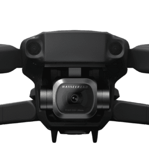
The Leica Aibot provides a complete UAV solution for surveying, mapping and construction. It enables fast data collection and an easy workflow that guides you through your project lifecycle providing you quick access to critical information to perform your day-to-day work.
Strong Partnership
The UAV used for the Leica Aibot surveying and mapping solution is provided by DJI, the world's leading manufacturer of UAVs. Together with Leica Geosystems, they build a strong partnership that drives UAV adoption in the surveying and construction industries.
System Integration
Strong system integration plays a vital role in delivering aerial data capture solutions. By fully leveraging DJI's innovative aerial devices with Leica Geosystems extensive expertise in high accuracy measurement sensors, the full potential of UAV technology will be unlocked.
The Future Surveyor
Developments created by this partnership help those operating in the surveying and construction industries who adopt the latest technology and software to help make the most informed decisions possible. The future surveyor will make use of UAV technology.